Golden Ridge Resources Drills 7.42 Metres of 4.94g/t Au and 48.44g/t Ag (468.31g/t AgEq) at the Heritage Project, Newfoundland and Labrador
Golden Ridge Resources Drills 7.42 Metres of 4.94g/t Au and 48.44g/t Ag (468.31g/t AgEq) at the Heritage Project, Newfoundland and Labrador
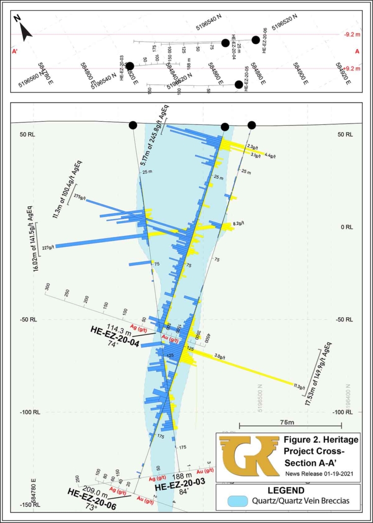
Kelowna, British Columbia– February 10, 2021 – Golden Ridge Resources Ltd. (“Golden Ridge” or the “Company”) (TSXV: GLDN) is pleased to announce results from holes HE-EZ-20-07 to HE-EZ-20-09 drilled at the Eagle Zone, as part of the Company’s recently completed 5,182 meter diamond-drill program at the Heritage epithermal Au-Ag project (“Heritage” or the “Property”), located along Highway 220, near Point May, Newfoundland and Labrador. All three holes hit significant intersections of epithermal veining, alteration, ginguro textures and Au-Ag mineralization. Notably, hole HE-EZ-20-07 is one of the deepest holes drilled on the Property to date and was targeted to test the downdip intersection of the sub-vertically dipping high-grade zone intersected in holes HE-EZ-20-04 and HE-EZ-20-06 (see news release dated January 19th, 2021). HE-EZ-20-07 successfully extended this zone at depth and intersected the highest-grade interval of the campaign to date returning 7.42m of 4.94g/t Au and 48.44g/t Ag (468.31g/t AgEq). The zone remains open at depth and along strike.
Highlights
- Ongoing drilling from the Eagle Zone continue to increase its dimensions which currently covers at least 750m in strike length, 50m in width and 250m in depth, representing a large, robust and open Au-Ag epithermal system.
- Hole HE-EZ-20-07, which intersected 7.42m of 4.94g/t Au and 48.44g/t Ag (468.31g/t AgEq) is one of the deepest holes drilled on the Property to date and strongly suggests that grades increase with depth.
- Historical drilling within the northern part of the Eagle Zone focused on shallow depths (historic drilling generally focused on depths of less than ~100m), and the down dip extension of the high-grade zone encountered in HE-EZ-20-07 was further tested in holes HE-EZ-20-16 to HE-EZ-20-21 (assays pending).
- Holes HE-EZ-20-08 and HE-EZ-20-09 continued to build on Au-Ag mineralization at depths of ~200m within the southern part of the Eagle Zone. Epithermal-style mineralization intersected within the zone remains open at depth.
Only 1,914m of drilling have now been assayed and reported from the recently completed 5,182m program, representing only 37% of the total meterage drilled. Additional results to report include assays for holes targeting the Turpin, Pinnacle and Lunch Spot Zone’s situated along a 2.5km magnetic anomaly, as well as additional holes at the Eagle Zone.
“We are extremely pleased that all drill hole results to date from the Eagle Zone have intersected significant intervals of strong epithermal-style veining, alteration with gold and silver-rich mineralization. While previous operators focused on relatively shallow depths, hole HE-EZ-20-07 which intersected 7.42m of 4.94g/t Au and 48.44g/t Ag (468.31g/t AgEq) and was designed to test the down-dip extension of a zone previously discovered by the Company, has shown us that the Eagle Zone is much bigger than we originally thought, and it continues to grow with ongoing results. We also are eagerly awaiting results from the project’s Turpin, Pinnacle and Lunch Spot Zone’s which lie 800 meters to the east of the Eagle Zone, where epithermal style mineralized bodies extend along a 2.5km parallel magnetic anomaly.” stated Golden Ridge CEO, Michael Blady.
Table 1 – Significant Intercepts
| HOLE ID | FROM (M) |
TO (M) |
INTERVAL (M)2 |
Au (g/t) | Ag (g/t) | AuEq (g/t)1 | AgEq (g/t)1 | AuEq Gram Meter |
| HE-EZ-20-07 | 175.82 | 183.24 | 7.42 | 4.94 | 48.44 | 5.58 | 468.31 | 41.44 |
| HE-EZ-20-08 | 127.07 | 155.35 | 28.28 | 0.61 | 26.90 | 0.97 | 99.66 | 27.37 |
| HE-EZ-20-09 | 178.80 | 207.50 | 28.70 | 0.30 | 22.90 | 0.60 | 68.36 | 17.35 |
Scroll to the right to see the table data.
1 Gold (AuEq) and silver (AgEQ) equivalent grades are calculated using 100-day moving-average metal prices of gold at US$1,888/oz. and silver at US$25.08/oz. Gold equivalent grade is calculated as AuEq (g/t) = Au (g/t) + Ag (g/t) * 0.0133. Silver equivalent grade is calculated at AgEq (g/t) = Ag (g/t) + Au (g/t) / 0.0133. The factors for gold (0.0133) and silver (0.0133) will change depending on the metal price. The metal price numbers listed above were used to determine the conversion factors presented herein. Metal recoveries have not been applied in the gold-equivalent calculation.
2 The intervals reported in these tables represent drill intercepts and insufficient data are available at this time to state the true thickness of the mineralized intervals. All gold values are uncut.
Table 2 – 2020 Drill Collar locations for the Eagle Zone (up to HE-EZ-20-09 reported, remaining assays pending)
| HOLE ID | EASTING (NAD27, Zone 21) |
NORTHING (NAD27, Zone 21) |
AZIMUTH | INCLINATION |
| HE-EZ-20-01 | 584699 | 5196378 | 120° | -75° |
| HE-EZ-20-02 | 584744 | 5196272 | 004° | -55° |
| HE-EZ-20-03 | 584823 | 5196539 | 114° | -84° |
| HE-EZ-20-04 | 584872 | 5196526 | 300° | -74° |
| HE-EZ-20-05 | 584867 | 5196503 | 300° | -75° |
| HE-EZ-20-06 | 584886 | 5196520 | 300° | -73° |
| HE-EZ-20-07 | 584900 | 5196516 | 300° | -73° |
| HE-EZ-20-08 | 584702 | 5196390 | 120° | -70° |
| HE-EZ-20-09 | 584699 | 5196423 | 103° | -75° |
| HE-EZ-20-10 | 584564 | 5196409 | 120° | -45° |
| HE-EZ-20-11 | 584436 | 5196248 | 115° | -45° |
| HE-EZ-20-12 | 584393 | 5196078 | 120° | -45° |
| HE-TZ-20-01 | 585194 | 5195830 | 300° | -84° |
| HE-PZ-20-01 | 584709 | 5195027 | 10° | -55° |
| HE-PZ-20-02 | 584722 | 5195057 | 30° | -55° |
| HE-PZ-20-03 | 584777 | 5195155 | 30° | -45° |
| HE-LZ-20-01 | 584810 | 5195245 | 30° | -50° |
| HE-LZ-20-02 | 584923 | 5195388 | 46° | -45° |
| HE-EZ-20-13 | 584774 | 5196321 | 11° | -60° |
| HE-EZ-20-14 | 584692 | 5196417 | 120° | -70° |
| HE-EZ-20-15 | 584907 | 5196517 | 275° | -70° |
| HE-EZ-20-16 | 584887 | 5196639 | 120° | -65° |
| HE-EZ-20-17 | 584893 | 5196660 | 120° | -65° |
| HE-EZ-20-18 | 584913 | 5196677 | 120° | -65° |
| HE-EZ-20-19 | 584893 | 5196660 | 120° | -84° |
| HE-EZ-20-20 | 584934 | 5196725 | 120° | -65° |
| HE-EZ-20-21 | 584922 | 5196709 | 120° | -65° |
| HE-EZ-20-22 | 584803 | 5196516 | 120° | -65° |
Scroll to the right to see the table data.
A total of 5,182 metres were completed during the 2020/21 drill campaign in 28 drill holes. Assays from the remaining holes are pending and they will be released to the market once received and compiled.
Qualified Person:
Dr. Stephen Amor, PhD, PGeo, technical advisor to the Company, is the Qualified Person as defined by National Instrument 43-101 who has reviewed and approved the technical data in this news release.
Ball Creek Termination
Effective February 9th, 2020 Golden Ridge and Orogen Royalties Inc. have agreed to terminate the July 2019 Ball Creek Option Agreement. Consideration to Golden Ridge for its early termination is $15,000 in cash and the surrender of 149,573 Golden Ridge payment shares previously received by Orogen.
Acknowledgments:
Golden Ridge Resources acknowledges the financial support of the Junior Exploration Assistance Program, Department of Natural Resources, Government of Newfoundland and Labrador.
About Golden Ridge Resources:
Golden Ridge is a TSX-V listed exploration company engaged in acquiring and advancing mineral properties located in British Columbia and Newfoundland. Golden Ridge owns a 100% interest in the 1,700-hectare Hank copper-gold-silver-lead-zinc property located in the Golden Triangle district, approximately 140 kilometres north of Stewart, British Columbia and has a portfolio of exploration projects in Newfoundland.
Golden Ridge Resources Ltd.
Mike Blady
Chief Executive Officer
Tel: (250) 768-1168
Website: www.goldenridgeresources.com
Cautionary Note Regarding Forward-Looking Statements
Certain statements contained in this news release, constitute “forward-looking information” as such term is used in applicable Canadian securities laws. Forward-looking information is based on plans, expectations and estimates of management at the date the information is provided and is subject to certain factors and assumptions, including: that the Company’s financial condition and development plans do not change as a result of unforeseen events, that the Company obtains required regulatory approvals, that the Company continues to maintain a good relationship with the local project communities. Forward-looking information is subject to a variety of risks and uncertainties and other factors that could cause plans, estimates and actual results to vary materially from those projected in such forward-looking information. Factors that could cause the forward-looking information in this news release to change or to be inaccurate include, but are not limited to, the risk that any of the assumptions referred to prove not to be valid or reliable, which could result in delays, or cessation in planned work, that the Company’s financial condition and development plans change, delays in regulatory approval, risks associated with the interpretation of data, the geology, grade and continuity of mineral deposits, the possibility that results will not be consistent with the Company’s expectations, as well as the other risks and uncertainties applicable to mineral exploration and development activities and to the Company as set forth in the Company’s Management’s Discussion and Analysis reports filed under the Company’s profile at www.sedar.com. There can be no assurance that any forward-looking information will prove to be accurate, as actual results and future events could differ materially from those anticipated in such statements. Accordingly, the reader should not place any undue reliance on forward-looking information or statements. The Company undertakes no obligation to update forward-looking information or statements, other than as required by applicable law.
Neither the TSX Venture Exchange nor its Regulation Services Provider (as that term is defined in the policies of the TSX Venture Exchange) accepts responsibility for the adequacy or accuracy of this release.
Williams Property Location Map

 Golden Ridge Resources Intersects Epithermal Au-Ag Mineralization at Depth in...